Explore
Featured
Recent
Articles
Topics
Login
Upload
Featured
Recent
Articles
Topics
Login
Upload
Search Results for 'maps web'
maps web published presentations and documents on DocSlides.
Ten Years of Gulfport GIS
by kittie-lecroy
Survival and Evolution . since . Hurricane Katrin...
A Summary of Some Key Points from Chapters
by daisy
1 and 2 of Peterson. On page 1 Peterson indicates ...
ESRI UC2013 Plenary Plenary
by calandra-battersby
10.2. Roadmap. Incremental software releases. Con...
DESIGN OF WEB MAPS FOR NAVIGATION PURPOSE Zhilin LI, Lilian PUN-CHE
by debby-jeon
Paper Maps Visual communication & data storage Di...
Advanced Mapping Techniques
by calandra-battersby
PRESENTED BY. Dan Cory. Jesse Gebhardt. What we a...
Mapping Spatial Data from Multiple Sources
by stefany-barnette
Olivia Gill, Bruce Smith and John Dawson. Explosi...
VEGA-GEOGLAM Web-based GIS for crop monitoring
by caroline
and decision support . in agriculture. Evgeniya . ...
Technology Tidbits for Teachers
by conchita-marotz
Cindy Sheets. ‘Our kids will spend the rest of ...
A Javascript
by myesha-ticknor
Implementation of the Binary DIS Protocol. . Do...
X3D Sensor-based Thermal Maps for
by ellena-manuel
Residential and Commercial Buildings. Felix G. . ...
(DOWNLOAD)-Développer avec les API Google Maps - Applications web, iPhone/iPad et Android: Applications web, iPhone/iPad et Android (InfoPro)
by owensdevlin
Cet ouvrage s\'adresse aux d233veloppeurs web et a...
GIS for Information Technology
by helene
Prepared by . Information . Technology Services . ...
state of the Art: The Utility of Graphic Design in Contempo
by pamella-moone
David Hill – 8501 GIS Survey Presentation. Conv...
SAAQIS
by danika-pritchard
Part 1. The National Environmental Management Act...
Using Bing platform controls to build great Windows apps
by faustina-dinatale
Altaf Gilani. Senior Program Manager. David Robin...
Florida Department of Environmental Protection
by faustina-dinatale
Mobile GIS Solutions using ArcGIS Online. Sara Wa...
2014 ESIP Summer Meeting
by alida-meadow
July 8–11, 2014 . |. Frisco, Colorado. Advanci...
Part I: GIS Tools for Water Planners
by lois-ondreau
and. Part II: Sierra Nevada Conservancy . GIS Wat...
How does a community utilize ESRI’s
by min-jolicoeur
ArcGIS Online functionality and incorporate. into...
Five Free Data Tools
by marina-yarberry
(No Coding Required). Norm Lewis, Ph.D. / Associa...
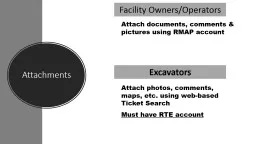
Attac hments Attach photos, comments, maps, etc. using web-based Ticket Search
by pasty-toler
Must have RTE account. Attach documents, comments...
1 Tech Tuesday: Using the Internet
by tatiana-dople
1 Tech Tuesday: Using the Internet http://pbdd....
DOI Section 508 Outreach Event
by pasty-toler
DOI Section 508 Outreach Event Integrating Access...
FISE State of progress meeting 23rd May in Brussels
by khadtale
21/05/2019. Producing. . maps. . for. FISE. ECH...
Problem Statement Many roadways that are prone to flooding lack a
by margaret
city controlled contiguous . alert system to warn ...
Load More...